Meassuring our frontiers: Panama – Costa Rica
Panama, Casco Viejo, Casco Antiguo
This past week, La Prensa published an article about the need to renew the posts that mark the Panama- Costa Rica frontier, as they are old and some of those posts are even missing. When I read it, I couldn´t help but to smile. My grandpa put those posts down back in the 40´s, boy! they´ve lasted!!!
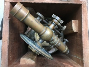
Of course, he wasn´t the first one to draw physicaly a line between the two countries. Here is a whole page of its history (Wiki). But of course, I grew up listening to the stories. When he passed away, my cousin gave me to safe keep the instrument he used to meassure. It is in a wooden box that weighs “like a bad marriage”. Talk about quality: the box is still hard and solid, no termite has dared to taste it.
I had seen photos of my grandfather dressed up in full jungle gear: boots, big hat, long sleeves. Think early explorers in Africa. He used to tell us how they would go up and down mountains in the middle of the forest. The team would include engineers, workmen, and – of course- someone who played the guitar. Fighting boredom was as important as fighting mosquitoes. At night, only the sounds of the jungle, and the sounds of the guitar, under that amazing sky filled with stars.
The other challenge, believe it or not, was coming up with names for the hills and places they were marking. He would laugh at how creative they were at the beginning, really thinking things through. But at some point, after weeks of jungle, animals, insects, sweat and carrying all the equipment, they just started to name things after the first thing that came to mind. Yes, that´s the true story of how and why Panama ended up with a number of hills called “lizard” and “white stones”. Not to mention “flat creek” and “fat sugar cane”. Now, I know that other countries have faced similar challenges and met them with a similar approach. How else could you explain Greasy Creek? It´s in my bucket list, have to go see it!


